Research & Development
JAXA promotes three research and development programs and a fundamental research program that underpins them.
Weather information technology
Vortex turbulence that forms behind a passenger aircraft is referred to as wake turbulence. Consecutive take-offs and landings require an interval, or separation, during which wake turbulence by a preceding aircraft fades out. The separation minima for heavy aircraft is about 2 minutes under current operational practices. However, existing separation standards will be insufficient to manage the increased air traffic expected in the future.
In reality, it is not always necessary to wait for as long as 2 minutes, because the way wake turbulence moves and recedes depends largely on weather conditions, such as wind. By detecting weather conditions and predicting changes in wake turbulence behavior, it is possible to shorten the interval between consecutive take-offs and landings.
Hills and valleys or buildings around an airport may also alter the airflow, causing wind shear*1 and or turbulence. Such disturbance of the air (low-level turbulence) affects the operation of aircraft flying at low altitudes so much that a flight may be cancelled because of aborted landing. Instructions on the danger of low-level turbulence in advance allow a pilot to judge the timing of the optimal approach.
These technologies offer promising solutions for expanding airport capacity and improving the in-service rate.
*1: "wind shear" refers to sudden changes in wind speed and/or wind direction over a relatively short distance in the atmosphere. Typical types of wind shear include vertical shear and horizontal shear.
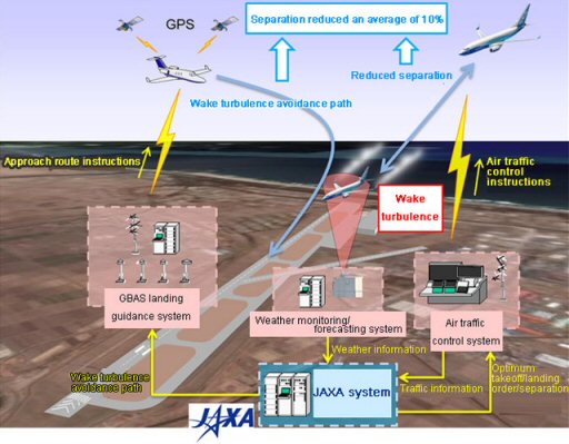
Conceptual view of system operation to reduce aircraft separation with wake turbulence prediction
LOTAS: Low-level Turbulence Advisory System
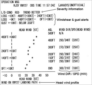
Using the latest weather remote sensors that are less expensive than conventional components, JAXA has been developing the Low-Level Turbulence Advisory System (LOTAS), a system that provides real-time turbulence information in the landing approach path, together with prediction data for 10 minutes later, to support airline pilots and dispatchers.
The system can also send turbulence information to pilots via the Aircraft Communications Addressing and Reporting System (ACARS), a text-based digital datalink system that is installed in aircraft cockpits.
ACARS Text Information
The turbulence information at each altitude level and the prediction for 10 minutes later supports the airline dispatchers when giving landing instructions to pilots.
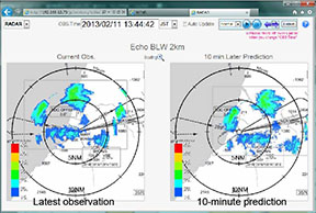
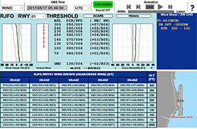
Radar Echo Display
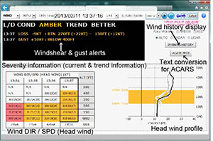
Wind Information
Such turbulence information assists the pilots in preparing for local wind disturbances and making the proper decisions with regards to landing timing, which results in safer and more efficient operation, including the reduction of go-arounds.
In addition, JAXA and the Japan Meteorological Agency (JMA) jointly developed the Airport Low-level Wind Information (ALWIN) system, a turbulence information system based on LOTAS technologies, but which uses the existing weather Doppler Lidar* and Radar systems already installed at some airports, instead of LOTAS weather remote sensors. ALWIN was put into practical use at Tokyo International Airport (Haneda) and Narita International Airport in 2017.
* Airport weather Doppler Lidar: A device that measures the wind at low altitudes under non-precipitation conditions by using laser beams to detect the movement of aerosols (fine particles) in the atmosphere.
ALWIN: Airport Low-level Wind Information
ALWIN provides low-level wind information (wind direction, wind speed, wind shear*1, and turbulence, etc.) around airports. Using data measured by airport-based Doppler Radar and Doppler Lidar, ALWIN automatically detects wind shear and low-level turbulence mainly Induced by local terrain and buildings. The wind information is converted into graphical data, and then transmitted to airline operators and pilots in cockpits. Compared to existing wind shear alerts that use radio voice communications, ALWIN can provide more detailed and precise wind profiles in real-time. This helps pilots and operators monitor sudden changes in winds on final approach paths for safer landings.
ALWIN has been in operation at Tokyo International Airport (Haneda) and Narita International Airport since April 2017.
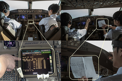
Pilots in the cockpit check wind information on an approach path using ALWIN
(Photo courtesy of Japan Airlines)
SOLWIN: Sodar-based Low-level Wind Information
The SOLWIN system provides low-level wind advisories to pilots and dispatchers by combining ALWIN’s advisory function with SONIC CORPORATION’s sonic remote sensing (Doppler Sodar) technology. Sodar is capable of detecting low-level wind in all weather conditions, and is also more affordable compared to the Radar and Lidar technologies. Currently, the SOLWIN is in trial operation to accumulate data for verification towards its practical implementation, mainly in regional airports.
An example of a SOLWIN web screen. Upper half of the screen shows current wind profiles (wind direction, wind speed, updraft/downdraft, etc.) with observed values and graphs, while the bottom half shows the history of the wind profiles.
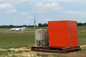
A SOLWIN Sodar (red box) installed at Tottori Airport, with JAXA’s jet flying test bed "HISHO"
| ALWIN | LOTAS | SOLWIN | |
|---|---|---|---|
| Features |
|
||
| Range of Information | Aircraft take-off/landing paths Under 1000 ft. elevation |
Aircraft take-off/landing paths Under 500 ft. elevation |
Area directly above sensors Under 300 ft. elevation |
| Wind Information | Horizontal wind (headwind, cross-wind) | Horizontal wind (mainly headwind; can also detect cross-wind) | Horizontal wind (headwind, cross-wind) Vertical wind |
| Sensors Used | Airport Doppler Radar Airport Doppler Lidar |
Small-Scale Doppler Radar Small-Scale Doppler Lidar |
Doppler Sodar |
| Positives | Wide detection range | Same features as ALWIN under 500 ft. elevation | Can detect vertical wind Low cost |
| Negatives | Relies on existing airport infrastructure | Not yet developed system for practical use | Limited detection range |
As of November 7, 2018