Research & Development
JAXA promotes three research and development programs and a fundamental research program that underpins them.
Situational Awareness and Visual Enhancer for Rescue Helicopter (SAVERH)
JAXA has been developing pilot assistance technology named "Situation Awareness and Visibility Enhancer for Rescue Helicopter (SAVERH)" in order to enhance operational safety and mission capabilities of rescue helicopters.
The SAVERH helps pilots to fly helicopters safely in the Degraded Visual Environment (DVE) by displaying visual cues with data from sensors and range finders integrally. To date, we have been developing various systems for SAVERH, including the enhanced and synthetic vision systems, which is comprised of three-dimensional topographical display generated from IR images and terrain and altitude databases; and tunnel-in-the-sky navigation and guidance system.
Our ongoing challenge is to further mature the SAVERH technology with real operational settings into account.
Background
Pilot's situational awareness is significantly reduced in the Degraded Visual Environments (DVE), in particular, when flying at night or in low visibility conditions such as heavy clouds, fog, snow or dust, as well when there is the presence of obstacles. Flight in DVE increases the workload of the pilots as well as the risk of errors and consequent incidents. On the other hand, helicopters are expected to perform various missions, such as search, rescue, and transport, for emergency response and disaster relief under demanding conditions.
Research objectives (FY2020-FY2022)
In order to enhance operational safety of rescue helicopters in the Degraded Visual Environment (DVE), and to better support pilot to fly at night or in poor visibility conditions such as white out and brown out, JAXA develops the following DVE mitigation technologies.
- Incorporating long-waved infrared sensors (LWIR) and mid-waved infrared sensors (MWIR) into the SAVERH system.
- Enabling stable hovering at the altitude of 50ft (for simulated rescue missions) by making use of LWIR, MWIR and the multi-camera sensor pod that provide enhanced vision for sensors and improved correction of delay.
We also plan to develop pilot interfaces, image synthesis, instruments and guidance display, obstacle detection and display, etc., and conduct flight evaluation tests on the effectiveness of the developed systems and programs.
How SAVERH works
A footage from the flight evaluation tests of SAVERH in November 2018 at Taiki Aerospace Research Field, Hokkaido, Japan.
JAXA has been developing the SAVERH technology to support safe helicopter operations during the night and/or in poor visibility for search and rescue operations at times of disaster. With the SAVERH technology, outside conditions and flight status are displayed as visual information to a helicopter pilot.
-
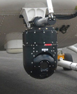
Sensor pod
- To obtain data from outside, a sensor pod containing a night vision camera (infrared camera), laser rangefinder, and other sensor is installed on the nose on JAXA’s research helicopter.
By detecting invisible infrared light, the infrared (IR) camera can capture what human eyes cannot view in the darkness as infrared images. The laser rangefinder measure distance to the obstacles on the ground and display the presence of obstacles such as power lines that pose a risk of contact, which helps the pilot to detect and avoid them.
-
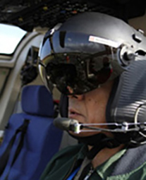
Helmet-Mounted Display (HMD)
- Information from the pod is displayed on the Helmet-Mounted Display (HMD), which a pilot can wear as a helmet. With HMD, the pilot can obtain necessary information that is projected on a visor while keeping his/her eyes outside the helicopter. As pilot moves his head wearing the HMD, the infrared camera installed outside the research helicopter changes its angle so that it can project infrared images of the direction where the pilot is actually facing.
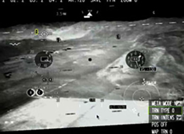
By overlaying the Tunnel-in-the-Sky for precise navigation on the synthetic 3D terrain generated from terrain database, the display helps pilots to grasp the depth, perspectives, and altitude, while clearly indicating the current and desired flight path.
Infrared (IR) display
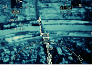
Obstacles display by laser rangefinder
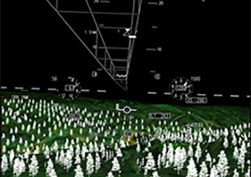
Tunnel-in-the-Sky on Synthetic 3D terrain