About us
JAXA Aviation helps to create a safer and more prosperous society with aeronautics-related research and development activities.
FLIGHT PATH No.21 | 2018 SUMMER
<Aeronautics in depth>
SAVERH
Helicopters are used for various purposes like search and rescue, supply delivery, and emergency transport during disasters. However, safe operation cannot be fully ensured in degraded visibility or at night.
JAXA has been conducting a research and development project named "Situational Awareness and Visual Enhancer for Rescue Helicopter" (SAVERH). This technology displays information to the pilot—based on images from a night vision camera and an infrared camera—for safe flying even at night or in other low-visibility conditions.
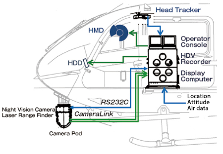
SAVERH System
Enhanced Flight Vision Systems (EFVS), which use infrared images for aircraft operation even at night or during degraded visibility, are already available for fixed-wing aircraft. These require the installation of head-up displays (HUDs) in the cockpit that display infrared camera and other images. However, pilots have to look in many different directions while operating helicopters, which means that HUDs do not fulfill their needs.
With SAVERH, a sensor pod containing a night vision camera, laser rangefinder, and other sensors is installed on the nose. Sensor information from the pod is displayed on the Helmet-Mounted Display (HMD) worn by the pilot. The camera pod tilts up and down and pans left and right according to the pilot’s head motion to direct the sensors to the direction of pilot's interst. The sensor information from the camera pod is sent to the computer installed inside the helicopter. Images are generated combining this information with flight data, such as helicopter location and attitude, and the images and data are displayed on the HMD. Moreover, areas that cannot be fully captured by the sensors are augmented with a 3D topographic image composed from digital terrain elevation maps. Because SAVERH combines sensor and other data with actual terrain, it can be described as one type of augmented reality (AR) technology. In this way, SAVERH provides the information needed by the pilot and expands their vision to maintain a high level of safety for flight at night and in other situations with degraded visibility.
Research on SAVERH was started in FY2008. Proof-of-concept tests combining various sensors have been conducted since then, as well as simulation tests with a total of 70 to 80 helicopter pilots. This technology has been improved based on pilots’ comments. Joint research has been underway since the initial stage with Shimadzu Corporation, which develops HMDs.
In particular, an original technology is adopted for displaying the sensor information on the HMD that utilizes JAXA’s human factors technologies researched since the 1990s. For instance, mountain forms based on maps and other data can be superimposed, but in some cases the projected ridgelines do not match the actual ones because of the height of mountain vegetation and trees or other causes. Even a small disparity causes misleading pilot cues, so an essential point is correcting the disparities for each type of data to ensure easier viewing, and providing information that the pilot can use.
SAVERH research is entering a new phase in FY2018. We plan to conduct research by imagining the situations in which this technology might be used, coming up with combinations of sensors that will be needed in those settings, offering easy-to-understand information that pilots require, and completing the system composed of these. Proof-of-concept tests will be carried out over the next two years to take another step toward practical use.
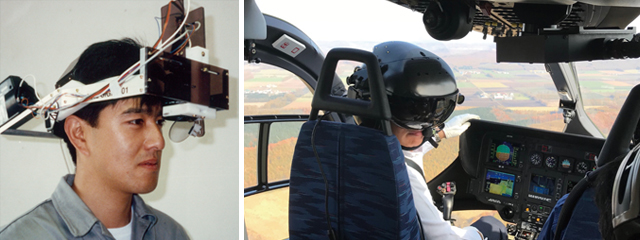
left:HMD prototype (around 1994)
right:Pilot wearing and evaluating the HMD made by Shimadzu Corporation